


By motorhome
Tourists in the Park


The Mincio River has always been Mantua's main defence and, starting from the 13th century, the city was additionally protected by the Serraglio, a wide territory between the upper lake, the Mincio and Po rivers, and Osone Nuovo and Fossaviva canals. The area was controlled by a complex system of sewers, moats and towers and, in case of extreme necessity, could be flooded by the Mincio and Po water, thus surrounding Mantua with a further defence behind Lake Paiolo. A valuable natural stronghold and evidence of how water could be a unique defence, the Serraglio has been protagonist of all the wars in Mantua's history.
 Download KMZ
  Download in GPX format
Points of interest
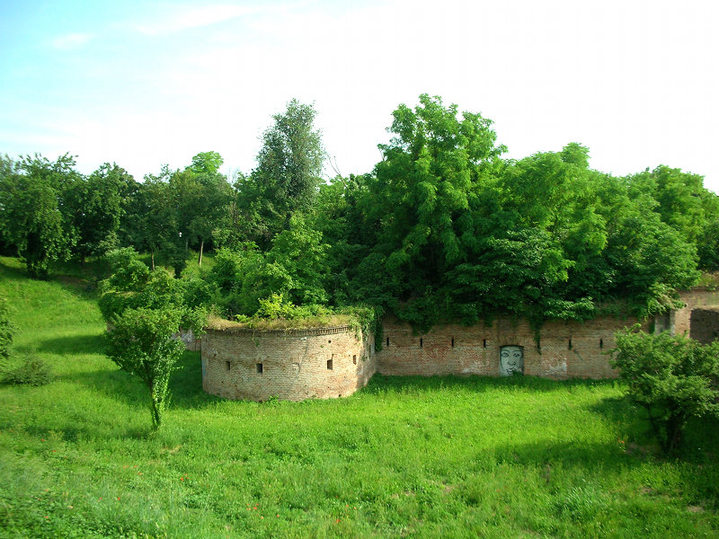
This historic-naturalistic itinerary follows the borders of the ancient Serraglio, a true symbol of the Gonzaga power and a fundamental element within Mantua's wider defence system. The itinerary encompasses military architectures, works, monuments and battle scenes, which have been particularly significant for the 18th and 19th-century military history. In Piazzale di Porta Giulia the remains of 16th-century Cittadella di Porto can be visited. This fortified outpost defended the dam bridge (ponte-diga dei Mulini), which not only led into the city but was also a fundamental waterwork to control the lakes' level. The Periurban Park bike trail leads then to 19th-century Fossamana and Frassino lunettes, which strengthened the eastern side of the fortress, and to the stronghold known as Rocchetta di Sparafucile: the stronghold is what remains of the ancient fortifications of the village of San Giorgio, which once rose up at the eastern end of the bridge of the same name. San Giorgio's bridge leads to an area known as San Nicolò, characterized by the former military cemetery ground and by portions of the ancient city walls, which for centuries defined the image of the fortress city. The imposing Fortress of Pietole, surrounded by thick vegetation, overlooks the Mincio River. Napoleon's army started building this fortress, designed by general François de Chasseloup-Laubat, and the Habsburg army completed it in the first half of the 19th century. Continuing along the Mincio riverside, the itinerary leads to Governolo, where Conca del Bertazzolo and the River Museum can be visited. The Po riverside leads then to Borgoforte, where it is possible to visit Forte Centrale, and to Motteggiana, where the remains of the Fortress of Noyeau are located. Both fortresses were part of a double bridgehead, which was built by the Habsburg corps of engineers on the Po River to grant transit over the river, complete the defence of the fortress of Mantua and, more broadly, to defend the Empire's south-western frontier. The following destinations are Curtatone and Montanara, where important events of the Italian Unification took place. It is possible to visit a monument dedicated to all the university students who died between 1848 and 1945; the church of Immacolata Concezione in Montanara, where a cannon ball is kept in the exact point where it had fallen; the ossuary monument containing the remains of those who fought in the battle of 29 May1848; the memorial stone dedicated to an Austrian official; the commemorative stone bearing the names of those who fell during the battle of 29 May 1848. On the road back to Mantua, a monument and a memorial stone by sculptor Pasquale Miglioretti are dedicated to Italian Unification patriots who were executed here between 1851 and 1855. Ponte-diga dei Mulini (the dam bridge) leads back to Cittadella.
Description
The first part of the itinerary unfolds within Mincio Park. It follows bike trails, embankment paths and lightly trafficked ordinary roads.
Itinerary conditions
The itinerary is about 71.6 km long, completely level or with very low-gradient slopes. It is mostly paved, but there are also long stretches on dirt roads. Embankment paths are little shadowed. There are no water provision points outside of towns. On some portions of the itinerary it is possible to travel by boat (ferry service between Governolo and Mantua, and between Grazie and Mantua) or by train (Borgoforte - Mantua), taking bicycles on board.
Directions
From piazza Porta Giulia take strada Montata, then the bike trail of Mantua Urban Park (ciclovia 1s.a), pass the Fossamana lunette and reach the Fortress of Sparafucile. Along Strada Cipata it is possible to deviate towards Frassino (deviation is at km 1.0); otherwise keep right and follow the bike trail towards Mantua (ciclovia 1d): you thus border San Giorgio bridge and Lago di Mezzo (middle lake) until a pedestrian crossing in Piazza Arche. Go along Piazza Arche, Via Pomponazzo and Via Trieste until the pedestrian crossing by Via Cardone. Take Via Cardone, go up the embankment and turn right. Turn left on the dirt road after the parking lot, and follow Vicolo Maestro until the intersection with Via diga Masetti; cross Via diga Masetti and make a very short stretch on Via Ariosto. Take the dirt path that leads to the Baden Powell Public Gardens. Cross the gardens and take the subway under Via Brennero. After the subway, turn immediately left on a narrow dirt path, which borders Via Brennero for a stretch, and then winds across the vegetation near Vallazza. Shortly before the descent that leads to the kennels, take the second path on the left. Go past the descent that leads to Bosco Virgiliano, then the water purification plant, and reach the intersection with Via Guerra. There, keep left and reach the end of the dirt road on the embankment (ciclovia 1d). Turn left again on the descending path that crosses a wetland. Keep left after the wood and go along via Argine Mincio (ciclovia Destra Mincio EV7), then on Via Mincio and Via Bevilacqua that, after crossing Via Dosso (Provincial Route - SP 33) leads to Governolo. From there, continue on Via Po Barna towards Correggio Micheli, leaving the Mincio riverside and reaching the Po (ciclovia Sinistra Po EV8). Keep left at the roundabout in Correggio Micheli and take Via Molinara. Pass under the bridge of Romana nuova (SS 413), reach the crossing and take Via Argine Po until the intersection with Via Po San Giacomo-San Nicolò. Turn right and reach the village of San Giacomo Po. Then continue towards San Nicolò Po, which you will reach after passing under the A22 motorway bridge. When entering the village, turn left on Via Argine San Nicolò, which later becomes Via Argine Po. Continue along Via Arginelli towards Boccadiganda and then on Via Fornace towards Borgoforte. There, by the railway, turn left on Via al Ponte (Provincial Route - SP 54) then turn right in the subway under the railway. Near the railway station turn left again on via Roma; in piazza Matteotti turn right on via Parmense and the SP 56 (Provincial Route), which leads to Forte Centrale. After visiting the fortress go back for a stretch on the SP 56, then keep right and take the SP 55, which runs along the Fossaviva canal towards Ponteventuno. In Ponteventuno turn left and reach the village of Serraglio. After the village cross the SP 57 and go along via Santa Chiara until the roundabout that crosses the SS 420 (State Route). Cross the roundabout and go for a stretch along via Morante until the intersection with the SS 10. Turn right towards Mantua. By turning left at the first crossing and taking via Francesca, you reach Grazie. By going straight on you continue instead towards Mantua. By turning right and taking via dei Toscani after the Osone Nuovo canal, at Quattro Venti, you can reach the village of Montanara. By going straight on you continue instead towards Mantua. Pass the traffic light at Angeli and turn left on via dell'Aldriga. At the end of the paved road take the bike trail on the left. The bike trail runs mostly on a dirt road along lago Superiore (upper lake) until Belfiore. There, it joins again the ordinary road in via Pascoli. At the end of Via Pascoli take the urban bike trail (ciclovia 1d) towards Cittadella. Reach the dock of the Mincio Rowing Club. Border the dock until the end of Via Santa Maria Nuova. Then turn right on Via San Giovanni Bono, cross the railway and turn right again on Via San Michele. The subway at the end of via San Michele leads back to piazza Porta Giulia.


